
Hawaii COVID-19 Screening Sites (as of 4:30 p.m., March 16, 2020) via Hawaii Dept. of Health To help manage available healthcare resources for the public statewide, the DOH advises everyone to take the following steps: 1. Stay home if you…

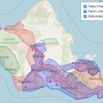
Building a spatial crop land cover timeline of the Hawaiian Islands

Efforts to reduce imports and increase self-sufficiency could instead export profits and jeopardize local farms.

This study combines data from local food hubs to quantify local agricultural production and pricing information.

https://public.tableau.com/shared/QZXHNS5XP?:display_count=n&:origin=viz_share_link This chart shows companies who have hired lobbyists for 2019-2020, their registered lobbyists, the employers of those lobbyists (based on contribution reporting by candidates), and finally the office, candidate and volume of contributions made in in 2019. The chart…
HICROP input variables include topographic, edaphic, and climatic variables to identify spatial niche suitability for selected crops. The topographic and edaphic variables are: slope, soil depth, soil drainage, and soil pH. First, make some basic functions Model funcitons # Call…